
Basics About Navigation
Lines on the Charts
There are two kinds that we would like to point out. Firstly those lines that go straight up and down (down and up if you prefer), and then there are those that go straight from right to left, (or left to right if you prefer).
These first ones are called Latitude and Longitude lines. 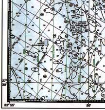 Those lines that run from top to bottom of the chart are called Longitude (please note the are also Longitude lines if they run from bottom to top). Notice on your chart that as they go from right to left the Longitude numbers increase in size. This is because they are getting farther from England where they begin. You will also notice that the numbers on the other lines (the Latitude lines) that run horizontally on your chart (left to right or vice/versa) increase as you go from south to north (I'm writing this in the northern hemisphere, Florida, so everyone south of the equator just read upside down for now.)
For those that use GPS or DGPS it is these Latitude and Longitude numbers that are used to enter into the GPS equipment. Some folks just call them GPS numbers, but for clarity purposes lets just call them what they are, Latitude and Longitude (shortened to Lat/Lon).
Just a quick note about the GPS/DGPS system. it is this system that has been certified for Marine Safety and Navigation (click here for more) and has been implemented and is fully functional throughout the United States and many foreign countries.
Now, to program Lat/Lon numbers into your GPS you need to understand that there are two ways that a Lat/Lon can be expressed. First, there is the degree/minute/second expression and then there is the degree/minute/decimal of a minute expression. Note that there are sixty minutes in a degree of Latitude and Longitude and there are sixty seconds to every degree. There are 360 degrees (full circle) for both the Latitude and Longitude lines as the circle the earth.
Your GPS equipment can be configured to accept coordinates in either format listed above. However we suggest that you configure your GPS/DGPS to accept coordinates (numbers) in Degrees/Minutes/Decimal of a minute. This is what the vast majority use that do serious navigation with this equipment. This format of will look like the following:
27 degrees 54.876 minutes or 27-54.876 for the Latitude and,
082 degrees 27.225 minutes or 082-27.225 for the Longitude expression.
(Note: the zero on the Longitude is most frequently dropped when talking about Longitude in our area, but most GPS units will require that you enter the "0" in order to input a waypoint into your GPS unit).
Whatever you do, don't forget that pesky little decimal point or nothing will work properly. Anytime you want to find the decimal equivalent for seconds, just take the minutes and divide them by 60.For those of you that have not taken the USCG Auxiliary or US Power Squadron Boating Safety course (you should) or have forgotten your basic navigation that they teach, one degree of Latitude equals one nautical mile (6,076.11549 feet). You can figure out how far one degree of Longitude is in the area that you are boating and then you will be able to figure out distances from one point to the next as you are boating.
LORAN-C System
ed. Note: The LORAN-C system was discontinued by the government in US coatal waters in 2010, so use the following LORAN C information as historical reference only.
Secondly, there are those other lines that wander about diagonally without any reference to north or south. Also, they are in different colors. These "Lines of Position" are called LORAN-C. This part gets technical, but here we go anyway; when you have found or selected a place on the chart that you want to go to, you will select the same color "Lines of Position," then use dividers and the scale to determine the coordinate "Numbers" or for them old salts the Time Delays (TDs).
The southeastern part of the United States uses the 7980 GRI and within this grid there are four secondary W, X, Y, and Z to pick from. The greater Tampa Bay area uses the 7980 W and Y. A LORAN-C receiver will give you these TD Numbers automatically and they look like 14356.8 by 44689.0 (in the Tampa Bay area). Other parts of the country will use other grids and different secondaries.
It is important to use the correct TD secondary just like you cannot use two Latitudes to find your position. There are very few places that you can find that will tell you which secondary are preferred. Weak Industries, Inc. has computer software that lists every saltwater county in the United States including the Great Lakes, and listed by each county is the preferred GRI and the TD Secondary.
LORAN-C derived Latitude and Longitudes
The LORAN-C equipment will also give you a representative Latitude / Longitude for every TD it produces. just don't use them in your GPS if you want to find anything! That conversion will not be accurate enough.
To do reasonably accurate conversions you will need some computer software to find out the Latitude / Longitude for any pair of TDs. Once again, Weak Industries' software does this job very nicely.
(Ed Note 2010: WAAS GPS, though highly touted by the GPS manufacturers as accurate, is a system that is not approved by the USCG for Safety Of Life At Sea.)
Just a short comment regarding the WAAS/DGPS. this system is in the development stages and may not be ready for implementation until around the year 2008, provided they get all the bugs worked out. This WAAS system is being developed by the Federal Aviation Administration (FAA) and will be used primarily for aircraft and is unlikely to be certified for Marine Safety and Boating Navigation. Even though most of the major manufacturers are advertising and selling it for marine use, the WAAS system is not recognized by the USCG or any other maritime organization for safe navigation at sea. (For more information, click here)
Finding The Right Coordinates For Navigation.
The United States Coast Guard produces books called the "Light List." In these books the list the navigation buoy coordinates for every lighted marker in the United States waterways. Then there are the "Notice To Mariners" that express recent changes to the locations of markers and buoys. These are the authority!
The other way is to stop at the markers you wish to use and write down the Lat/Lon, just one suggestion, write down the coordinates next to the buoy or marker at a point that will put you into the channel safely. you don't want to hit that marker in the dark!
Navigation is a serious matter unless you don't care about the safety of your passengers and your property.
Remember, it aint no fun running aground!
Capt Rod & Susie Stebbins
8626 Chadwick Drive,
Tampa, FL 33635-6209
USA
Http://www.weak-industries.com/
![]() Florida Saltwater Fishing Offshore in St. Petersburg-Tampa to Index
Florida Saltwater Fishing Offshore in St. Petersburg-Tampa to Index